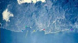
This is a photo of the Bay of Tenacatita from space (white arrow). The white dot is La Manzanilla, and heading south (to the right) the yellow dot is Tamarindo (see link on Links page) The red dot is Melaque and Barra de Navidad and the purple dot is Santiago which is close to Manzanillo. To the left (North) the green dot is near Boga de Iguana and the Blue Bay resort (see links) and the blue dot is Tenacatita.
This is a photo taken from the Space Shuttle from about 50 miles up in space. You are looking down on a section of Costa Alegre Mexico with the land in the top half of the photo and the ocean in the bottom half with a thin strip of white sand dividing the two. The shoreline is mostly straight with the exception of two fairly large Bay's that are like half circles. One of these Bay's is the Bay of Tenacatita. The land part is medium sized mountains and there are a few lines which are highways in the area and a cloud or two.